Information Guide
Map of South Africa Showing the 9 Provinces & Cities
A map is showing South Africa and the surrounding countries with international borders, with South Africa’s provinces, provinces boundaries, provinces capitals, and major cities.
South Africa is a country located in the southernmost part of the African continent. The country is renowned for its varied topography, great natural beauty and cultural diversity making it a one-stop location for tourists.
Page Contents
Map of South Africa and 9 Provinces
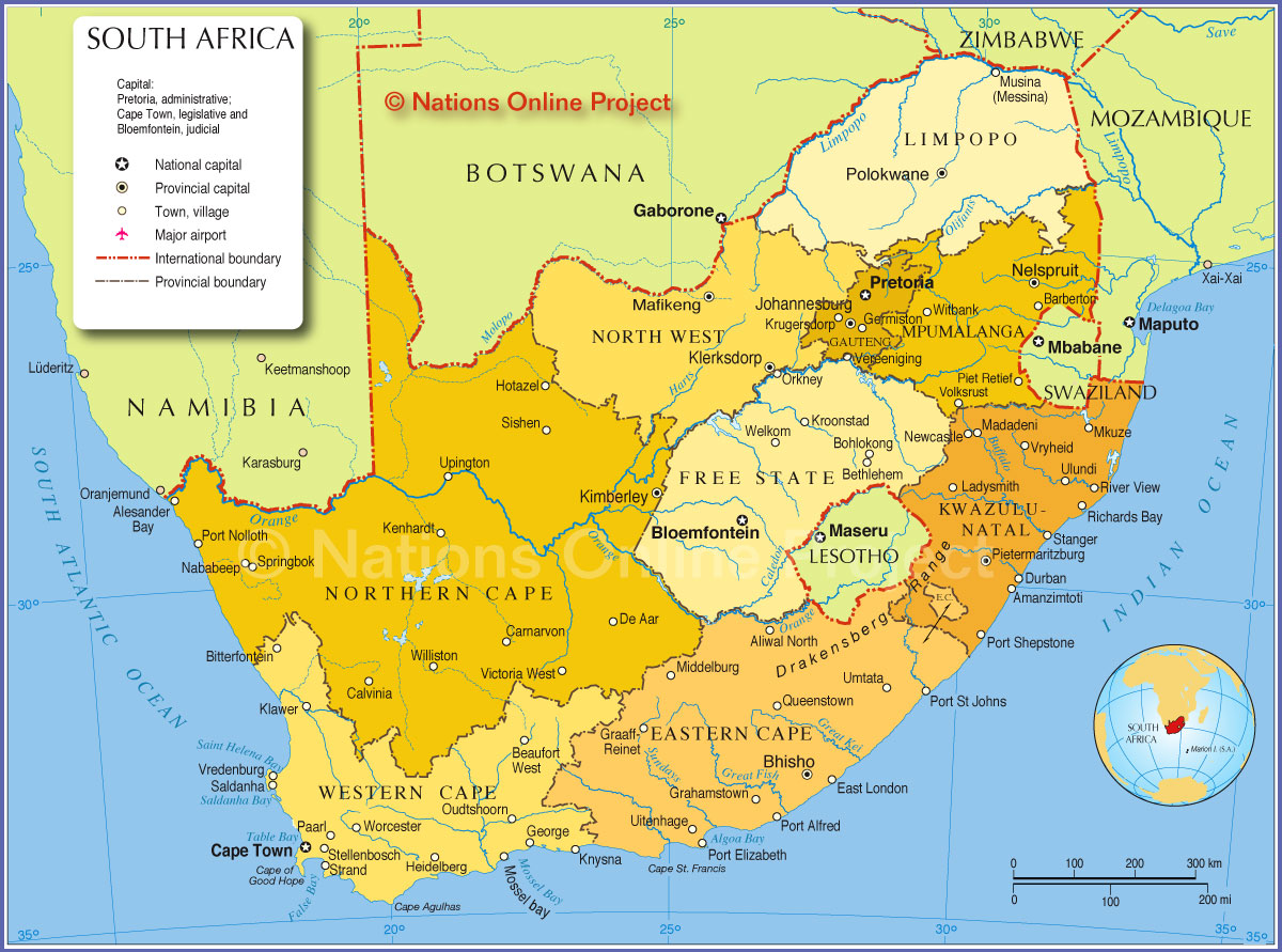
South Africa has nine provinces including Eastern Cape, Free State, Gauteng, KwaZulu-Natal, Limpopo, Mpumalanga, Northern Cape, North-West, and Western Cape.
With over 60 million people, South Africa is one of the most populous countries in Africa and in the world. The country covers an area of 1,221,037 square kilometres (471,445 square miles). South Africa has three capital cities with the executive, legislative, and judicial arms of government based in Pretoria, Cape Town and Bloemfontein respectively.
South Africa is bounded to the south by a coastline that stretches along the South Atlantic and Indian Oceans. To the north, the country is bordered by Namibia, Botswana, and Zimbabwe. To the east and northeast, the country is bordered by Mozambique and Eswatini and it surrounds the enslaved country of Lesotho.
9 Provinces of South Africa
1. Eastern Cape
Eastern Cape is the second largest province in South Africa with a land size of 62,238 square miles. The province is located in the south-eastern part of South Africa with Bhisho its capital city.
Other cities in the Eastern Cape province include Alice, Butterworth, East London, Graaff-Reinet, Grahamstown, King William’s Town, Mthatha, Port Elizabeth, Queenstown, Uitenhage, Zwelitsha.
2. Free State
Free State is the third-largest province in South Africa with a land size of 50,126 square miles. The province is located in the centre of the country with Bloemfontein being its capital.
Free State is also the eighth-most populous province in South Africa with a population of about 2.8 million people. The province is also among the richest in South Africa with agriculture and mining being the primary economic drivers.
Other cities in Free State include Bethlehem, Jagersfontein, Kroonstad, Odendaalsrus, Parys, Phuthaditjhaba, Sasolburg, Virginia, Welkom.
3. Gauteng
Gauteng is a province located in the centre of the country and is home to the nation’s administrative capital Pretoria. The province is the smallest in South Africa covering a total land area of 7,018 square miles.
The capital of Gauteng is Johannesburg which is the largest city in the province and one of the largest cities in South Africa. Furthermore, despite its relatively small land size, Gauteng is the most populous province in South Africa with a population of over 13 million people.
It is also worthy of note that Gauteng is home to one of the largest gold deposits in the world.
Other cities in Gauteng province include Benoni, Boksburg, Brakpan, Carletonville, Germiston, Johannesburg, Krugersdorp Randburg, Randfontein, Roodepoort, Soweto, Springs, Vanderbijlpark, Vereeniging.
4. KwaZulu-Natal
KwaZulu-Natal is the second-most populous province in South Africa with a population of about 11 million people. The province has a land size of 36,433 square miles with Pietermaritzburg as its capital city.
The KwaZulu-Natal province is located in the east of the country and borders the Indian Ocean, Swaziland, Lesotho, and Mozambique. The province was formed in 1994 after the merging of the Natal Province and the KwaZulu region.
Zulu is the most dominant language with 77.8 % of residents using the language. The largest city in the province is Durban.
Other cities in KwaZulu-Natal include Durban, Empangeni, Ladysmith, Newcastle, Pinetown, Ulundi, Umlazi.
5. Limpopo
Limpopo is the fifth-largest province in South Africa. The province covers a total land area of 48,554 square miles. The Limpopo province is located in the north of the country and is named after the Limpopo River.
The capital of Limpopo is Polokwane which is also the largest city in the province. The province also has a population of about 5.7 million residents.
Other cities in the Limpopo province include Giyani, Lebowakgomo, Musina, Phalaborwa, Polokwane, Seshego, Sibasa, Thabazimbi.
6. Mpumalanga
Mpumalanga province is located in the northeastern part of South Africa. The province covers an area of 29,535 square miles and has a population of over 4.2 million people.
The capital city of Mpumalanga province is Nelspruit which is also the largest city in the province. Mining is among the main economic activities in the province with Mpumalanga being the biggest producer of coal in the country accounting for up to 83% of the total national production.
Other cities in Mpumalanga region is Emalahleni, Nelspruit, Secunda.
7. North West
The capital city of North West province is Mahikeng. As the name implies, the province is located in the northern part of the country and borders Gauteng, Limpopo, Free State, and Northern Cape provinces as well as several districts of Botswana.
North West has a total land size of 40,495 square miles with a population of over 3.7 million people where Tswana is the dominant language accounting for 63.4% of the total population.
Mining is the primary economic driver of the province accounting for half of the province’s GDP. The largest city in the province is Rustenburg which has a population of 104,612 people.
Other cities in North West province include Klerksdorp, Mahikeng, Mmabatho, Potchefstroom, Rustenburg.
8. Northern Cape
The capital city of the Northern Cape Province is Kimberley which is also the largest city in the province with a population of 225,160 residents. Northern Cape is the largest province in South Africa with a total land size of 143,973 square miles.
The Northern Cape Province is located in the western part of South Africa and borders the North West, Western Cape, Eastern Cape and Free State provinces, the Atlantic Ocean, Namibia, and Botswana.
Mining and agriculture are the chief economic activities with the two sectors employing about 57% of all employees.
9. Western Cape
The Western Cape province is the fourth largest province in South Africa with a total land size of 49,986 square miles.
The province is strategically located on the southwestern edge of South Africa and is also the southernmost part of Africa.
The Western Cape province has a population of over 6.2 million people making it the fourth most populous province in the country. The provincial capital city of Western Cape is Cape Town with about two-thirds of the provincial population residing in it.
Other cities in the Western Cape province include Bellville, Constantia, George, Hopefield, Oudtshoorn, Paarl, Simon’s Town, Stellenbosch, Swellendam, Worcester.